and the distribution of digital products.
Understanding GEODNET: A Comprehensive Overview
- GEODNET is transforming global positioning services with a decentralized Real-Time Kinematics (RTK) network, providing precise, cost-effective GPS and GNSS corrections. Offering centimeter-level accuracy, GEODNET supports high-precision applications like autonomous vehicles (full self-driving), agricultural automation, and drone deliveries.
- Founded in 2021 by Mike Horton, GEODNET benefits from his extensive experience, including over 25 years of GNSS and RTK expertise. Horton previously co-founded Crossbow Technology, pioneering MEMS-based sensor systems for aerospace and agriculture.
- In just two years, GEODNET has expanded to over 10,000 RTK base stations globally, making it the largest RTK network in the world and surpassing centralized competitors like Trimble. This rapid growth has led to $2 million in annualized revenue, a 455% increase from the previous year.
- GEODNET's ecosystem has grown through strategic partnerships that showcase its RTK capabilities. These include collaborations with Boson Motors, Wingbits, Propeller, and Agri Automation, covering applications from precision agriculture to advanced flight tracking and survey-grade mapping.
GEODNET is transforming global positioning services by building a decentralized Real-Time Kinematics (RTK) network that delivers precise, cost-effective corrections for GPS and other Global Navigation Satellite Systems (GNSS). Traditional GNSS systems often have inaccuracies of 10 to 20 feet, which limits their effectiveness for applications that require precise geolocation. GEODNET addresses this challenge by providing centimeter-level accuracy, which is crucial for high-precision applications such as autonomous vehicles (full self-driving), agricultural automation, and drone deliveries.
Founded in 2021, GEODNET utilizes a Decentralized Physical Infrastructure Network (DePIN) model, which significantly reduces the capital and operational costs of building a global RTK network. By distributing the costs among infrastructure owners, GEODNET has managed to cut costs by 90% compared to traditional models. This innovative approach has enabled GEODNET to deploy over 10,000 base stations worldwide in less than two years, making it the largest RTK network in the world. The partnership with the US Department of Agriculture to support tractor auto-steering demonstrates the practical impact and scalability of GEODNET's model.
BackgroundTeamGEODNET was founded in 2021 by Mike Horton, a veteran in the field of GNSS and RTK technology with over 25 years of experience. Horton's journey towards founding GEODNET began with an attempt to build a global RTK network using a centralized model. However, the high capital costs, complex site acquisition processes, and infrastructure expenses made scaling a traditional network impractical. This led Horton to embrace a DePIN approach, ultimately resulting in the formation of GEODNET.
Mike Horton holds both a B.S. and an M.S. in Electrical Engineering from the University of California, Berkeley. During his time at Berkeley, Horton began experimenting with early silicon microelectromechanical systems (MEMS) sensor technology, which laid the foundation for his career. In 1995, Horton co-founded Crossbow Technology. Crossbow Technology specialized in MEMS-based sensor technology, focusing on commercial aerospace applications. The company became a leader in this niche, receiving FAA approval for its attitude and heading reference systems, which replaced traditional gyroscopes with MEMS-based solutions. Horton's contributions to innovation were recognized in 2003 when he was named one of the top young innovators under 35 by MIT Technology Review.
After the sale of Crossbow Technology to Moog Inc. in 2011, Horton continued to pursue his passion for entrepreneurship. He has since been involved in multiple ventures, with GEODNET being his latest endeavor.
Investors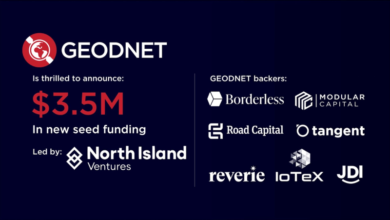
GEODNET has successfully raised capital through several funding rounds:
- Private Token Sale (July 5th, 2023): Raised $1.50M with investments from Borderless Capital and IoTeX.
- Seed Funding Round (February 27th, 2024): Raised $3.50M from Borderless Capital, Santiago R Santos, North Island Ventures, IoTeX, Modular Capital, and four other investors.
- Strategic Funding Round (April 16th, 2024): Raised $2.00M with investments from Pantera Capital, CoinFund, Santiago R Santos, and VanEck.
- Strategic Funding Round (October 29th, 2024): Raised an undisclosed amount from Animoca Brands and ParaFi Capital.
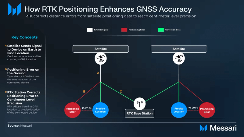
Real-Time Kinematics (RTK) is a method used to enhance the precision of position data provided by Global Navigation Satellite Systems (GNSS), such as GPS. Without RTK, GNSS positioning can often have an error range of 10-20 feet. An RTK base station, installed on the ground, receives the GNSS signal and corrects the positioning error, achieving accuracy within 1 centimeter of the true location. Such hyper-precise positioning is crucial for advanced use cases such as drone deliveries, autonomous vehicles (full self-driving), and augmented reality (AR) applications.
GEODNET'S DePIN Model for RTK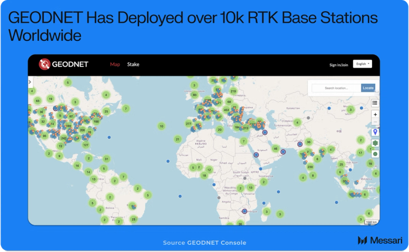
GEODNET is a DePIN that aims to provide a globally distributed RTK correction service. Instead of following the traditional centralized model, which is cost-prohibitive and requires significant infrastructure investment, GEODNET has adopted a decentralized approach that distributes the capital expenditure (CapEx) and operational expenditure (OpEx) among infrastructure owners. This model bypasses the high costs of real estate and permits, allowing the network to scale rapidly while providing low-cost RTK correction services.
In just two years, GEODNET has deployed over 10,000 RTK base stations across the globe, surpassing the centralized 5,000-node network operated by Trimble. This rapid growth has enabled GEODNET to generate $2 million in annualized revenue, reflecting a 455% increase from the previous year.
How GEODNET WorksThe GEODNET network is built on a community-driven model where individual operators purchase and install RTK Base Stations, also known as Satellite Miners, on their property. These base stations receive GNSS signals and provide real-time correction data with 1 cm accuracy, which is then transmitted to GEODNET's cloud platform. In return for their contribution, base station operators receive daily GEOD tokens as rewards.
The GEODNET Foundation sells the correction data to end-users through multiple channels, and 80% of the revenue generated from these data sales is used to buy and burn GEOD tokens, which directly accrues value to the token holders.
GEODNET’S Architecture
GEODNET Base Stations monitor the total number of satellites, signal strength, multi-path interference, and station stability. This data is sent to AI-powered servers for quality evaluation, which ensures that only high-quality correction data is provided to end-users. By employing a decentralized approach, GEODNET effectively eliminates the high costs traditionally associated with RTK networks, including infrastructure and real estate expenses, making global RTK coverage feasible for the first time.
RTK base stations used by GEODNET cost around $700, with minimal maintenance expenses. This cost-efficiency, combined with the DePIN model, reduces deployment expenses by over 90%, paving the way for a viable global network that provides real-time, centimeter-level correction data.
GEODNET’S Flywheel Effect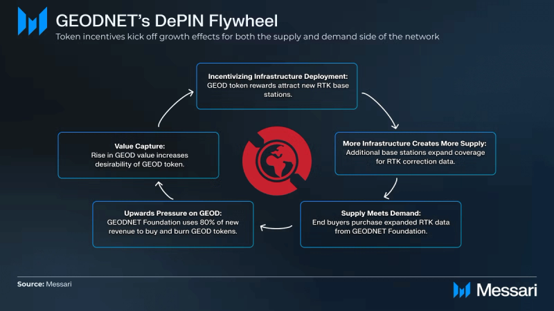
The decentralized nature of GEODNET has created a flywheel effect that drives growth on both the supply and demand sides. As more base stations are deployed, the network's coverage expands, making the correction data more valuable to end-users. This, in turn, attracts more users and drives further revenue, which encourages additional base station deployments.
Currently, GEODNET has over 10,000 RTK base stations and is on track to reach 20,000 nodes to meet demand across North America and Europe. With a target of 80,000 to 100,000 nodes, GEODNET aims to achieve full global coverage within the next 2 to 5 years.
Benefits of GEODNETGEODNET's decentralized approach to RTK correction services offers several benefits:
- Cost Efficiency: By distributing the costs of deployment among individual operators, GEODNET has reduced the cost of building a global RTK network by 90%, making centimeter-level precision affordable for a wide range of users.
- Scalability: The DePIN model allows GEODNET to scale rapidly without the need for expensive real estate or lengthy permit processes.
- Reliability and Precision: GEODNET base stations provide real-time GNSS correction data with accuracy up to 1 cm, which is crucial for high-precision applications like autonomous vehicles (full self-driving), agriculture, and consumer devices.
- Token Incentives: Base station operators are incentivized with GEOD tokens, creating a robust and engaged community that supports network growth.
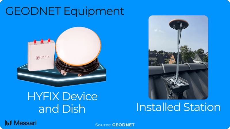
The GEODNET mining process is straightforward: participants purchase and install a geodetic-grade GNSS antenna (Base Station) on their property, connect it to the internet, and start sending data to GEODNET's cloud platform. This data is used to correct GNSS positioning errors, and operators are rewarded with GEOD tokens.
For optimal signal quality, base stations must be installed in locations with an unobstructed view of the sky, following the 10-degree elevation angle rule. The GNSS Signal-to-Noise Ratio (SNR) is used to monitor signal quality, and GEOD tokens are issued based on the quality of the GNSS signal. Sites with strong signal quality ensure that correction data provided to the network is both reliable and precise.
TokenomicsGEOD OverviewThe GEOD token is the native utility token of the GEODNET network, used to reward contributors and facilitate transactions within the ecosystem. GEOD tokens are primarily used to reward users who have installed GEODNET Base Stations (Satellite Miners) and to pay for RTK data services. Additionally, GEOD is used to participate in project governance.
The GEOD token is available on multiple networks:
- Polygon: Available as an ERC-20 token with trading pairs like GEOD/USDT, GEOD/MATIC, and GEOD/USDC on exchanges such as Gate.io, MEXC, QuickSwap, and Uniswap.
- Solana: Available as an SPL token using the Wormhole Native Token Transfer (NTT) framework. Trading pairs include GEOD/SOL on platforms like Orca, Raydium, and Jupiter.
- IoTeX: Available on the IoTeX blockchain, with trading pairs like GEOD/IOTX on Mimo.
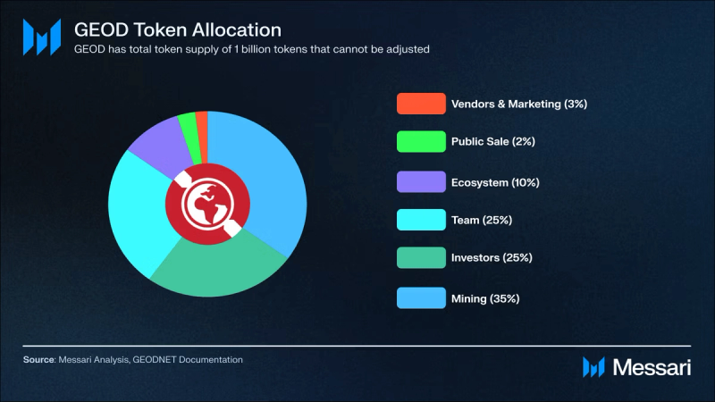
The total supply of GEOD tokens is capped at 1 billion, with no plans for additional issuance. Tokens are distributed according to specific allocations:
- Mining: 35% (350 million)
- Team: 25% (250 million)
- Investors: 25% (250 million)
- Ecosystem: 10% (100 million)
- Public Sale: 2% (20 million)
- Vendor and Marketing: 3% (30 million)
The mining allocations are distributed to base station operators daily, adhering to a fixed mining schedule. The team, investor, and ecosystem allocations are subject to a multi-year vesting schedule.
Rewards SystemThe reward system for GEOD tokens incentivizes node operators who contribute to the network.
- Base Reward: Base stations earn a fixed rate of GEOD tokens per hour, starting at 2 GEOD/hour in July 2022. The reward halves annually, dropping to 1 GEOD/hour in July 2023, and then to 0.5 GEOD/hour in July 2024. Currently, nodes can earn up to 48 GEOD per day, depending on the base station type and incentives.
- Effective Reward: Actual rewards depend on the quality of data provided by the base station, such as the Signal-to-Noise Ratio of satellite signals. Rewards are adjusted based on the number of effective satellites tracked, encouraging high-quality contributions.
GEODNET uses a system of hexagons based on Uber's H3 grid to optimize global coverage. The first base station within a hex receives a Location NFT, entitling it to 100% of the base rewards for that area. Subsequent base stations share a rewards pool proportionally. In high-value areas identified as "Super Hexes," additional incentives are offered to encourage deployment. Stakers can also contribute GEOD tokens to activate rewards in these regions, benefiting both node operators and stakers.
Burn Mechanism and Value Accrual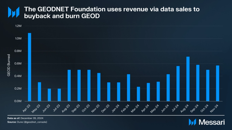
GEOD tokens also function indirectly as a payment method within the network. Although most RTK data transactions are in fiat currency, 80% of these payments are used to buy back and burn GEOD tokens.
Base Station Payback PeriodThe average payback period for a GEODNET RTK base station is approximately 153 days, making it one of the fastest in the DePIN sector. This quick return on investment encourages further expansion and strengthens the network's overall growth.
GEODNET's approach to tokenomics ensures a sustainable and incentive-aligned ecosystem that rewards both contributors and stakeholders while driving the long-term value of the network.
Ecosystem and Partnerships OverviewGeodnet is expanding its ecosystem through strategic partnerships across industries, enhancing RTK capabilities and extending reach:
- Boson Motors Partnership: At World Ag Expo 2024, Boson Motors showcased an autonomous electric truck using GEODNET'S RTK service, highlighting precise GPS navigation for agriculture.
- Wingbits Collaboration: Geodnet partnered with Wingbits, a decentralized flight-tracking network, to develop professional-grade ADS-B and RemoteID tracking nodes. Wingbits' network currently has 2,000 ADS-B stations, with plans to grow to 10,000 by 2025. GEODNET'S RTK service enhances the accuracy of Wingbits' nodes, improving air traffic monitoring and drone operations.
- Propeller Integration: Propeller, a worksite mapping company, integrated GEODNET'S GNSS stations to enhance survey-grade mapping for industries like construction and mining. Using data from GEODNET'S 9,000 GNSS reference stations, Propeller delivers high-accuracy maps to support global worksites, improving decision-making.
- Agri Automation Partnership: In October 2024, Agri Automation partnered with Geodnet to deploy RTK services in rural Australia and New Zealand, enabling reliable RTK coverage for autonomous farming solutions and boosting productivity.
- Quectel Wireless Solutions Collaboration: Quectel Wireless Solutions is leveraging GEODNET'S GNSS modules to target a wide range of IoT applications, including scooters and robotic mowers.
- ByNav Integration: ByNav has integrated GEODNET'S RTK services into its Automotive Advanced Driver Assistance Systems (ADAS) solutions. This collaboration enhances precision and safety in autonomous driving applications.
GEODNET provides decentralized Real-Time Kinematics (RTK) network services that offer cost-effective, centimeter-level accuracy. By utilizing a DePIN model, GEODNET has scaled its operations, surpassing traditional competitors and becoming the largest RTK network globally. With over 10,000 RTK base stations and growing revenue, GEODNET demonstrates the scalability and efficiency of its approach.
The network has formed partnerships with companies such as Boson Motors, Wingbits, Propeller, and Agri Automation to support various high-precision applications, including autonomous vehicles, agricultural automation, flight tracking, and survey-grade mapping. These collaborations extend GEODNET's reach and applicability across multiple industries.
GEODNET’s roadmap includes plans to expand its node network to achieve global coverage, refine its tokenomics with mechanisms like token burning, and encourage ecosystem growth through partnerships and technological integrations. The focus on cost efficiency, scalability, and reliability positions GEODNET to address the increasing demand for precise geolocation services.